

Tweet

>> Latest UK Pressure Situation <<
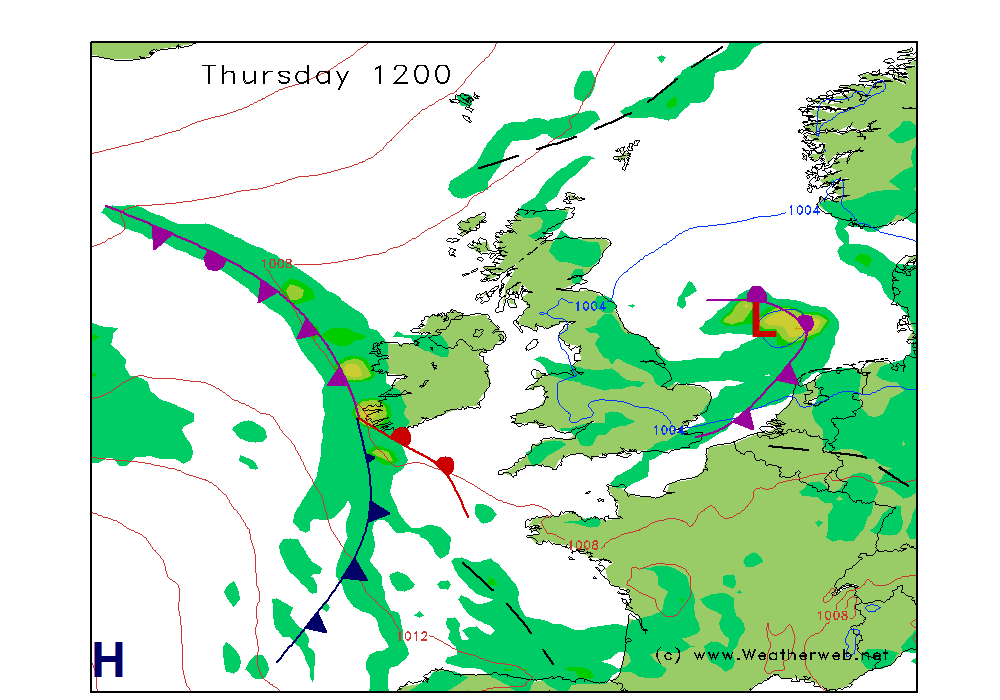
A slow deepening depression traking towards Denmark is moving away eastwards and filling. This maintains a fresh to strong cyclonic northerly flow through the North Sea Basin with 4/5 N to NE onshore winds from Shetland to Kent during the morning though winds will ease 2/3 N/NW Shetland to Humber, N/NE Wash to Kent, then 1/2 to calm and variable for all North Sea coasts by evening as pressure rises slowly from the west during the day. Cloudy along North Sea coasts during the day though with breaks during the afternoon Shetland to Tayside, viz poor with low cloud good in Scotland when cloud clears. Showers for a time through the morning Wash to Kent clearing into the afternoon with cloud lifting and breaking Tweed to Humber during the afternoon and Humber to Kent by and during the evening. Viz poor with cloud good where and when cloud breaks. Waves and swell high to start and during the morning north to south, decreasing to low by evening along all shores. For western coasts and shores from Western Isles, through the Irish Sea to Scilly and eastwards along Channel variable cloud with sunshine winds 1/2 variable likely calm by evening, Patchy cloud across northern Irish Sea, will extend to Bristol Channel by afternoon whilst patchy cloud runs along E. Channel shores eastwards from Scilly towards IoW.


>> Detailed astronomy forecast for your location <<
>> Get our famous weekend forecast sent to you by email each Thursday, click here <<
|
>> UK clear sky <<
Based on GFS updated: Tue 23 April 2024 16:25
|
Based on GFS updated: Tue 23 April 2024 16:25
| 6hr Rain warnings in next 24-hours
Yellow=5mm+ Red=10mm+ |
|---|
| Essex, Kent, E. Sussex |
| Essex, Kent, E. Sussex |
| London, Herts, Surrey, W. Sussex |
| London, Herts, Surrey, W. Sussex |
| Central Southern England |
| Central Southern England |
| Wilts, Dorset & E. Somerset |
| Wilts, Dorset & E. Somerset |
| South Devon & South Cornwall |
| South Devon & South Cornwall |
| N. Cornwall, N. Devon & W. Somerset |
| N. Cornwall, N. Devon & W. Somerset |
| North Wales |
| North Wales |
| Mid Wales |
| Mid Wales |
| South Wales |
| South Wales |
| West Midlands |
| West Midlands |
| East Midlands |
| East Midlands |
| East Anglia |
| East Anglia |
| Yorks (W), N Notts, N Derbs |
| Yorks (W), N Notts, N Derbs |
| York (E) & Lincolnshire |
| York (E) & Lincolnshire |
| NW England (south) |
| NW England (south) |
| NW England (north) |
| NW England (north) |
| Northern Ireland (East) |
| Northern Ireland (East) |